There are several good trail guides available at local shops for the metro Atlanta area. Check out the guide book for former SORBA president Alex Nutt call Mountain Biking Georgia (Falcon Press). Many good rides exist within 45 minutes from downtown Atlanta. Several books about rides in the North Georgia Mountains have been written and are also available at local shops. To check to see if the trails in Gainesville are open, call the Gainesville-SORBA hotline at 770-297-8319. For more trail resources, see the Georgia Links page or SORBA's website.
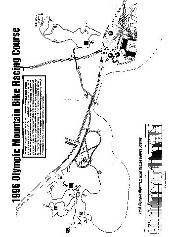
The Georgia International Horse Park is the home to the 1996 Olympic Mountain Bike Course. It reopened in March of 1998 for public riding. There are two loops of 3.3 miles with an optional 4 mile extension loop on the granite side. The "dirt" loop is not very technical but has several good climbs. Face Plant Hill is known as being one of the toughest spots to ride in the Atlanta area. It is a nearly vertical hill that drops down about 12-15 feet. An alternate route is provided for those not brave enough to ride it. One hill offers a potential over the bars experience for those that want to attempt to ride water bar drop offs. The "granite" loop takes riders over a large granite rock before dipping back down into singletrack. Parts of this side can get slick after a rain. The extension weaves in and out of single track and up and down rolling hills before coming out onto a large grassy field by the horse 3 Day Event course. Care must be used when at trail crossings as horses also use the park. Take I-20 to Conyers/Georgia International Horse Park (look for an Applebees and a Wal-Mart at the exit). Signs are posted at each exit ramp indicating the way to the Horse Park. Follow Walnut Grove Rd. and turn right onto Centennial Olympic Parkway. There will be a large sign for the Horse Park at that intersection. Go to the second light and make a right into the Park. Park at the "Steeplechase" (big white fence) on the right hand side past the apartments. Helmets are required.
Yellow River is operated by the Gwinnett County Parks Department. Trails are available for both horses and bikes. Each trail has markers as to what is allowed on it; however, all trails are open to hikers. The left loop is fairly flat but has a nice off-camber section by the river. It is good for less experienced riders. The right loop is quite technical and has a few good climbs. There are also some log jumps. Coming from downtown/I-285, take Stone Mountain Freeway/Hwy. 78 towards Stone Mountain to the West Park Place exit and turn right at the red light. Pass an Ingles on the right. The road then becomes two lanes. Turn right onto Juhan Road. The parking lot is about one mile on the left. The trailhead starts at the back of the parking lot.
Sope Creek is a National Park along the Chatahoochee River in Fulton County. It is accessible from several entry points, which are well marked by the National Park Service, off of Powers Ferry Rd. and Johnson Ferry Rd. There are two trails, the first of which is a flat, jogging trail that is packed on the weekends with walkers, joggers, and cyclists. The second trail is about 2 miles of single and double track through the woods. There are 2 tough rocky sections that beginners may wish to walk. The trails make for a nice mid-week ride but do not offer enough mileage for a serious workout. sections have flatted many tires. There is a small fee for parking.
Chicopee Woods in Gainesville provides some of the nicest, well kept singletrack in the area. There are at least 15 miles of trails in several loops, much of which is rolling non-technical singletrack along hillsides and through deciduous forest. For those that enjoy torturing themselves, the end one of the loops provides a 1/4 mile climb along a gravel road. One of the best spots on the trail is a double creek crossing. Views of local vegetation there are lovely. Take I-85 North to 985 North towards Gainesville. Take Exit 16/Oakwood and turn left off of the exit. Take a right at the first red light by McDonalds. Go to the end of the road and turn left. Take a right at the Chicopee Woods Nature Center sign and an immediate right back towards the golf course. This road takes you to the parking lot. Look for the signs A $1 fee is required, and trail maps are available. Map.
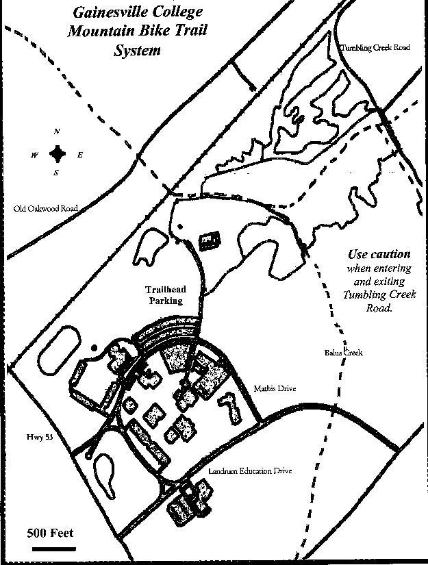
Gainesville College offers a 5.5 mile singletrack loop that is suitable as a solo ride for beginners or a nice addition to an afternoon of biking that includes Chicopee Woods for the more advanced rider. This loop is relatively flat and offers just a touch of technical difficulty with widely scattered roots. It starts off with a small downhill into the wetlands next to a creek. It then continues on flat singletrack until it ends at Tumbling Creek Road. After turning left onto the road, the trail head is a few hundred feet away on the left. The rest of the trail is twisty. In the fall, this trail hosts the Tumbling Creek Classic. From Atlanta, Take I-85 North to I-985 North. Take Exit 16/Oakwood and turn left off of the exit. Follow the signs to Gainesville College. Turn right into the campus. Parking and the trailhead are located towards the back of the campus.
Ft. Mountain State Park is located in Chatsworth. There are 3 loops: Beginner Loop-1.1 miles, Cool Springs Loop-Advanced-7 miles, Goldmine Loop-Strong Beginner/Intermediate-6.5 miles; East West Loop-Advanced/Expert-14 miles. There is quite a bit of climbing on these trails. The trails run the gammut from smooth doubletrack to technical singletrack. Take I-75 North to Exit 126. Take Hwy 411 towards Chatsworth and stay on it until you come into Chatsworth. Turn right on Hwy 52. Go 8 miles to the top of the mountain, and the park entrance will be on your left. Permits and maps can be obtained from the park office.
The Newnan/Windridge ATB Park is a 7 mile loop. The trail starts in the woods to the left of the parking lot. The first few hundred feet are tight and twisty, bringing a rider through some small drop offs. The rest of the first mile and a half is slightly downhill is compromised of large rocks that get slick when wet. Several switchbacks challenge even the most technically skilled riders. The trail then climbs for a few hundred yards before dropping onto a flat section with a 10-15 inch deep creek crossing. The flat section continues before coming to the "Bluffs," which consists of a series of short climbs. The next section of the trail is very steep, technical downhill. Rocks and roots make the bike skid beneath the rider. The final section of the trail goes by a pond along a flat section before cutting up a hill back to the parking lot. There is a $3 per rider fee; annual passes are available for $36. From Atlanta, take I-85 South to Hwy. 34/Newnan. Turn right at the top of the exit and follow the signs for Hwy. 34 Bypass. Turn right onto McFarmer Industrial Blvd. (Hwy 34 Bypass). Go several miles and over a bridge. Turn left onto Welcome Road. At the stop sign, turn left back onto Welcome Rd. Go 10.6 miles and turn right onto Glover Pond Rd. The Windridge ATB Park is the first driveway on the left. Parking is immediately to the left of the horseback riding ring.
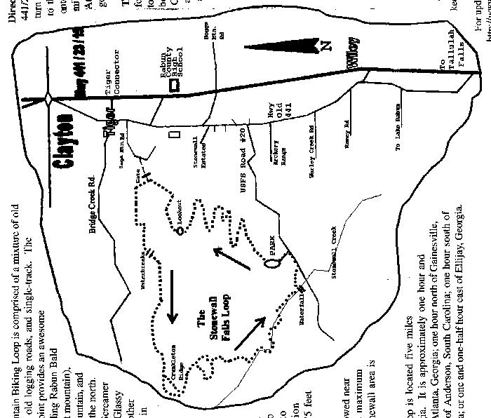
The Stonewall Falls Loop is located about 90 minutes north of Atlanta in Rabun County. The trail is composed of old Forest Service Roads, old logging road, and some singletrack. Most of the doubletrack is rocky, rolling terrain. There are a few longer but not steep climbing efforts. The loop is approximately 8 miles long. Camping is available in the near the waterfall area. The $2 fee goes towards trail maintenance. From Atlanta, take I-85 North to 985 North. Continue on 985 until it becomes Highway 441 heading towards Tallulah Falls and Clayton. From Tallulah Falls, go about 9 miles and turn left onto the Tiger Connector. Go one mile to a four way intersection. Turn left onto Highway Old 441. Go 2.5 miles and turn right onto US Forest Service Road 20. After one mile, turn right into the parking area.
McIntosh Reserve is located in Whitesburg in Carroll County, about 45 miles south of Atlanta. Within the park are approximately 16 miles of trails, all of which are open to hikers, cyclists, and equestrians. The terrain is non-technical and rolling. There are a few good climbs that test a rider's resolve. Most of the trails are 6-7 feet wide and offer plenty of room for passing other riders or to allow other trail users a wide berth. There are also several dirt roads that are open to riding. Several races are held at McIntosh each year. The reserve is operated by the Carroll County Parks and Recreation Comission. Admission is free for Carroll County residents; other must pay a small fee at the ranger station. From downtown Atlanta, take I-20 West to Douglasville/Arbor Place Mall. Turn left off of the exit onto GA Highway 5 to Whitesburg. At the stop sign, go straight through the intersection of Hwy. 5 and Alt. US 27. Follow GA 5 two miles to the park, which is on the left. There is a sign pointing towards the park entrance.
The Silver Comet Trail is part of the Georgia PATH project. When completed, it will extend 57 miles through Cobb, Paulding, and Polk Counties. The trail follows an abandoned CSX Railroad Corridor used by the Silver Comet Passenger Train. Future plans are for it to be linked with other trails and extend from Atlanta to Birmingham. It is open to everyone, including cyclists, roller bladers, walkers, and equestrians. Pedestrians have right of way. Pets must be on a leash as provided by county to county leash laws. Currently, the Silver Comet Trail is completely paved. It is relatively flat with several slight incline "grades" but no hills. Riding can be as easy (slower pace) or hard (fast pace in uncrowded areas) as the rider wants to make it. Street crossings are well marked. Bridges are enclosed on both sides with high fences to keep users safe. The trail is shaded by trees and is surrounded by private land with some beautiful scenery. The trail begins in Southern Cobb County and extends into Paulding and Polk Counties. To access the trail at its Southern-most point, Take I-285 to South Cobb Drive. Go north on S. Cobb Drive. Turn left onto the East-West Connector. Turn left onto Fontaine Rd. Parking will be immediately on your left. There is a second option for coming into the trail from South Cobb Drive. Turn onto left Cooper Lake Rd. and turn left onto Mavell Rd. The trailhead will be on the left. To access the trail from Paulding County (coming from Atlanta), take I-75 North to the Barrett Parkway Exit. Turn left (West towards the Kennesaw National Battle Monument) onto Barrett Parkway. Turn right onto Hwy. 120 (Dallas Hwy.). Turn left onto Hwy 93. Turn left onto Hwy. 278. Turn right at Home Depot. Go straight through the stop sign. The trail parking lot will be on the left. Please be courteous to other trail users so that the Silver Comet Trail will remain open to cyclists. Check out the Path Foundation Home Page for updates on the Silver Comet Trail construction progress.
Blanket's Creek is a trail built and maintained by SORBA on Army Corps of Engineers land bordering Lake Allatoona in Cherokee County. The Dwelling loop is 4 miles long and labeled as "intermediate" because of its lack of technical riding and smooth flow. The trail starts out with a one mile flat spin along a forest road. It then turns either right or left (look for directional arrows as it is run different ways on different days). There are a few shorts hills but no major changes of elevation. There is also a short Beginner trail called Mosquito Flats. The South Loop is the Advanced loop with log crossings, rock gardens, and off camber riding. New trails are currently being built. Helmets are *required,* and a $1 donation fee is suggested. Take I-575 to Exit 11, Sixes Road. Turn left at the top of the exit. Blanket's Creek is 1.8 miles on the left. Look for the signs. Blanket's Creek is closed when it is wet. Check the trail status here.
Big Creek in Roswell is the project of RAMBO-SORBA. There are about 6 miles worth of trails with several steep climbs and some rooty desents. From Atlanta, Take Ga 400 North to Holcomb Bridge Rd/Exit 7A. Turn right off the exit. Turn left onto Old Alabama Road. The trail is about 1/2 mile on the left or immediately past Belcourt Apartments. Park either in the old Cub Foods parking lot or at the trailhead.
The Dauset Trails are a trail system in Jackson, GA, about 45 minutes south of Atlanta. There are 17+ miles of rolling singletrack available to ride. There are a few climbs but nothing major. There are also several creek crossings. Although the trails are not technical, they are challenging as they can be ridden at speed. The trails are marked Beginner, Intermediate, and Advanced. Dauset is private property. The trails are well kept and are closed when they are wet; call ahead to make sure they are open 770-775-6798. The trails are open from sunrise to 10 pm. Click here for a map to Dauset.
Ft. Yargo is near Winder, GA at Ft. Yargo State Park. The trail system contains about 11 miles of trails, which are maintained by YABA. The trails are relatively rolling and very fast. A couple of rock gardens break up the speed. Take 85-North from Atlanta. Veer right onto 316 East towards Lawrenceville/Athens. Stay on 316 East for about 20 miles. Turn left onto GA Hwy. 81. There will be a sign for Ft. Yargo State Park. The park is about 2 miles ahead. Turn in the second entrance, which is also the main entrance. Park across from the tennis courts, and you will see the trail markings. The trail travels a specific direction each day.