|
Georgia Road and Trail Maps
Below are maps for different Georgia Road and Trail Rides. Most of the road rides originate in Atlanta and the metro counties. These maps came from various sources, which are noted if known.
Many clubs and teams have maps on their sites well. Check out the
Georgia Links page for their websites.
To see some of the maps, you must have the free Adobe Acrobat Reader or the Microsoft Word Viewer.
Ride Maps
- Alpharetta to Stone Mountain
-
Alpharetta Century, 6 Mile,
31 Miles,
64 Miles,
101 Miles
-
Alpharetta, Loop d'Alpharetta, Leaves
from Alpha Bikes
-
Alpha Roubaix, Leaves from
Alpha Bikes
-
Arabia Mountain Area, Dekalb County
-
Atlanta Cycling Monday Night Recover
Ride, Vinings
- Atlanta Cycling Silver Lake/Brookhaven Route,
Cue Sheet,
- Atlanta Cycling "You Are On Your Own
Century", Cue Sheet, Vinings
-
Ansley Intown
-
Baby Six Gap, 36 Mile,
48 Mile,
2009 Map
-
Ballground Ride, Forsyth County
-
Ball Ground Cue Sheets, 53 Miles,
68 Miles-Canton/Talking Rock,
Flying Spaghetti Monster,
Give Me Refuge,
Hammer and Goddess,
I Gotta Flat Bottom
-
Barnsley Gardens, 51 miler
-
Beautiful Back Roads Century, 2008 48 Mile
Loop, 2008 66 Mile Loop,
100 Mile Loop,
2011 48 Mile Loop,
2011 66 Mile Loop, starts at
the Bud Plant in Cartersville
-
Beyond Six Flags,
Cue Sheet
-
Beyond Allatoona, Kennesaw
-
Blairsville
-
Bicycle South 25 Mile Ride
-
Big Canoe Duathlon
-
Big Creek Road Ride, Ellijay
- Bike Dekalb
2003 Long,
2003 Short,
10 mile,
100 K West,
100K North
-
Biking for Burns, Forsyth County
-
Birmingham Ampersand Ride, Forsyth County. Starts at YMCA on Post Rd.
- Brasstown Bald Elevation
-
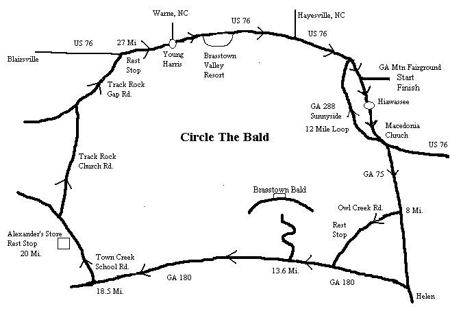
Brasstown Bald, Circle the Bald
-
Brooks Century,
65 Miles, 100 Miles
-
Brooks Road Race
-
Brookhaven Route
- Brookstone Ride Starts,
Directions to
Brookstone, Brasswell
Mountain Metric,
Indian Mounds,
Brookstone to Silver Comet,
Brookstone to Dallas,
Brookstone to Buckhead,
Indian Mound 2,
Brookstone Loop
-
Buckhead Bellyache
-
Burnt Mountain Elevation,Map,
Sunrise Ridge Route
-
Cartersville Century Route,
Old 25 and 50 mile options, 2005
55 Mile, 100 mile,
100 Mile Alternate Ending, Cartersville
- Cartersville Bud Brewery 27,
45, 65,
105, "May
2006 Ride," "May 2007
Ride," "May
2007 Ride #2," Barnsley
45 Mile, Barnsley 50 Mile
Loop, Barnsley 54 or 48 Mile
Loop, Barnsley 62 Mile Loop,
Fairmont,
Long Ride to Store,
Red Bud Loop,
Red Bud #2,
Red Bud #3,
Red Bud Loop #1,
Red Bud via
Mosteller's Mill and Union Grove,
Covington Bridge-Fairmont,
Salacoa Valley Ride 47 Miles,
Salacoa Valley Ride #1,
Adairsville with
Mountains, Barnsley/Adairsville
Map and Cue Sheet,
Young's
Mill-Adairsville, Adairsville
North Loop, North Loop to Dews Pond,
Fairmont-Variation on Carole,
Adairsville North Loop,
Farmville Loop-53 Miles,
Sonoraville,
Sonoraville Variation, Red Bud 50 Miles,
Fairmont/Johnson Mtn.,
Adairsville via Boyd Mtn.,
Fairmont via East Valley,
Hwy. 53 Store via Union
Grove, Adairsville w/Trimble
Hollow and McGill Mtn,
Fairmont with Carter
Extension, April 4 Ride,
Adairsville via McGill and Ward Mtns,
Ride to Adairsville
and Kingston,
Adairsville-Kingston 50 Miles,
Store 53 Loop 46 & 56 miles,
Red Bud 48/54,
Barnsley Through
Kingston Twice, Fairmount
via Vaughn Dairy, Store 53 Loop
47 & 50 miles, Hogan's Route,
Adairsville 52 Mile Ride,
Pine Log Loop,
Barnsley-Kingston Loop,
Store 53 Birthday Ride 2, Store 53
Loop #4, Barnesly 47/55,
Store 53 47/56,
Red Bud #3,
Adairsville/Kingston Loop #2,
Store on Hwy. 53 45 Miles,
Store 53 Loop 6B,
Fairmont Loop #2,
Store Loop 53 #6,
Adairsville Kingston Loop BBC 50,
Barnsley Gardens 50 Mile Loop 1
Fairmont Loop #3, Store 53 Loop #8,
Fairmont Ride #4,
Adairsville Loop #1 via Sunflowers,
Store 53 Loop #4,
Barnsley Gardens Loop #3,
Store 53 Loop #9 (flat route),
Barnsley Gardens Loop #4, Store
53 Loop #10, Euharlee Loop #1,
Barnsley Gardens Loop #1,
Euharlee Loop #2
(backwards), Euharlee Loop #3,
Judy's 80 Mile Ride/No Langford Option,
Sonoraville via
Mostellers Mill, Store 53 Loop #2,
Fairmont Loop #1,
Store Loop #7, Stacy's Dog Bite Ride,
Stacy's Dog Bite
Ride/Towe Chapel,
Thanksgiving Ride,
Adairsville North Loop #2, 53 Miles
to Kingston/Return via Shotgun,
New Rainbow from
Big Springs, Fairmont via Nalley,
Crane Eater Backwards,
49 Miles to Barnsley,
47 Mile Vaughn Dairy,
53 Mile Vaughn Dairy,
Adairsville via Trimble Hollow 54
miles, 45 to 55 Mile Hardin Bridge,
Cash Store via Union Grove,
Store on 53 via
Mosteller-Boone Ford,
Kingston Adairsville Trimble 53 Miles,
Kingston Adairsville
Trimble 55 Miles, 55 Miles to Barnsley,
55 Miles to Hunt's Gin Store,
Cash Store via Big Springs,
Adairsville-Lilypond 50 Mile,
Adairsville-Lilypond 46 Mile,
Adairsville-Lilypond 51-56 Mile,
44 Mile Arnold-Fairmont via
East Valley, 51-56 Mile
Salacoa-Fairmont via East Valley,
CraneEater-Hunts Gin Store,
42-50 Mile Dollar General on
Hwy. 53, 40 Mile Euharlee Loop,
49-61 Mile Euharlee Loop,
41 Miles Adairsville via
Griffin-Jarrett, 47-53
Mile Hwy. 53 via Boone Ford, 46-58
Barnsley via
Manning Return via Fire Tower, Chick's
Crane Eater, 43, 53, and 60
Mile Hardin Bridge, 50-62 Mile
Euharlee, 54-60
Mile Bud Plant to Adairsville No Return Climb,
51-57 Mile Adairsville,
50-57 Miles Adairsville
return Trimble Hollow,
48-55 Mile to Kingston
Return via CCC, Fairmont
40-50-57 Mile Loop, 47 Mile to
Barnsley return CCC
-
Cartersville (Sosebee) Bike Park
Directions to Bike Park,
More
Bike Park Info.,46 Mile Bike Park
Ride, 52-56 Mile Bike Park Ride,
46-50 Mile Ride to Hunt's
Gin Store, 63 Mile to
Pine Chapel Store, 43
Salacoa Valley, 53 Mile
Salocoa Valley,
46, 54, 60
Miles to Cash Store return via Mostellers Mill,
44-54 Mile to Hunt's Gin,
46-50 Mile Ride,
Fairmont from Sosebee,
46 Mile Bike Park Claudia & Russell,
64 Mile Sosebee Trimble
Hollow-Adairsville, 44, 46,
and 54 Mile Loop to TA, 53 Miles
to Fairmount,
49-54 Mile to Adairsville, No Climb Return,
45, 47, and 55 Mile
Sosebee to TA Loop, 44 Mile
Sosebee to Fairmont,
Judy's 62 Mile to Nicklesville Store,
Judy's 45-50 Mile to Hunt's Gin,
42 Miles to Hwy. 53 Store,
49 Miles to Hwy. 53 Store,
57 Miles to Hwy. 53 Store,
Short Euharlee Loop from Sosebee,
49 Mile Sosebee to Cash,
Return Towe Chapel, 51-54 East
Valley to Store on 53
-
Cartersville Ride
-
Chastain Park Ride
-
Chateau Elan
Duathlon
- Chatooga Century
-
Chattooga Century #2
-
Chubby Taylor 98 Miler, Starts on the
Rockmart Square
- Civil War Ride
- Cobb County,
County Line/Daily
Grind Coffee Start, Directions to Daily Grind Coffee
-
Cobb-Paulding Bikeable Roads
-
Coffee and Bagel 21 and 38,
50 miles, Coffee and Bagel website,
Coffee, Bagel, and
Burrito Loop, Starts from Marietta Square
- Cohutta Century
-
Combining
Intown Rides
- Covington Maps,
In Town Historic
Loop, Covington-Porterdale-Newton-Mansfield
42 miles,
61 miles, Oxford Loop 24 Miles,
41 Miles
- Covington Century
Maps, Starts at 2012 13
Miles, 2012 30 Miles,
2012 66 Miles,
2012 100 Miles
- Coots Lake Trailhead Starts,
Power Plant
Ride, Coots to Kingston,
Taylorsville Loop,
Coppermine Loop,
Euharlee Power Plant Loop,
Taylorsville-Euharlee
-
Cornelia, starts from Cornelia Plaza in
Cornelia, GA
- County Line Ride, Starts at
Brookstone Publix (Mars Hill and Stilesboro Rd. in Marietta
-
Covered Bridge
- Covington Century, 2006 route,
100
miles, 80 miles,
50 miles,
30 miles. Start: Project Adventure
(open only for the century. Park at Walmart on 278.)
-
Cumming 50 Mile Ride
-
Dahlonega 42 mile ride (no Gaps), Start
on the Dahlonega Square by the Smith House
- Dahlonega Rides,
Lumpkin Loop,
Clay Creek Falls
-
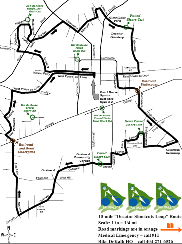
Decatur 10 Mile Loop
-
Decatur to Monastary
-
Decatur to Stone Mountain
-
Decatur Bicycle Suitability Map
-
Dunwoody/Brookhaven Area Rides Cue Sheet
- Five Gap North
-
Georgia Brevet 200 km
-
Georgia Gaps Map, Various Rides
- Georgia International Horse Park Start,
GIHP to Social Circle,
GIHP/Social Circle/HLC State Park,
GIHP/Rutledge,
GIHP/Rutledge/Madison,
GIHP 95 Miles,
GIHP 29 Miles, GIHP 31 Miles,
GIHP 35 Miles,
GIHP 37 Miles,
GIHP 50 Miles,
GIHP 56 Miles,
GIHP 62 Miles, GIHP 75 Miles,
GIHP 83 Miles, GIHP 91 Miles,
100 Miles
- Good Hope, Georgia Rides.
Starts from Good Hope City Park, 169 Hwy 83 South, Good Hope GA 30641.
10 Miles,
23 Miles,
30 Miles,
48 Miles,
50 Miles
-
Green Tour, Sandy Springs
- Habersham Bicycles,
Clairmont Loop,
Clarkeville Loop,
Great White Ride,
Hefner Loop,
Mealor Loop,
Start Directions
-
Hills of Habersham County Ride
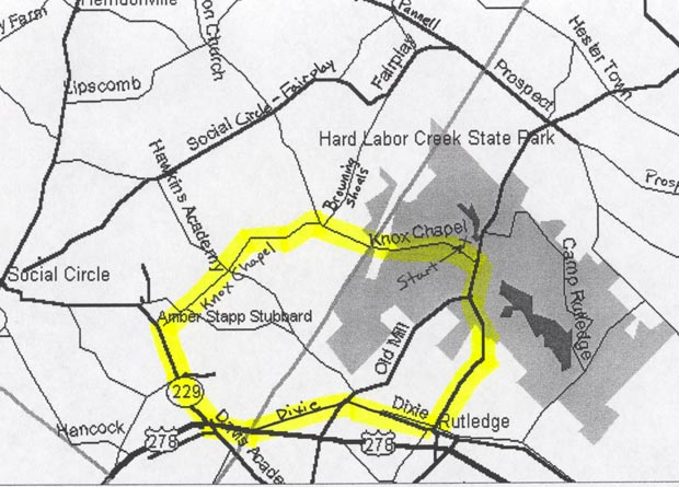
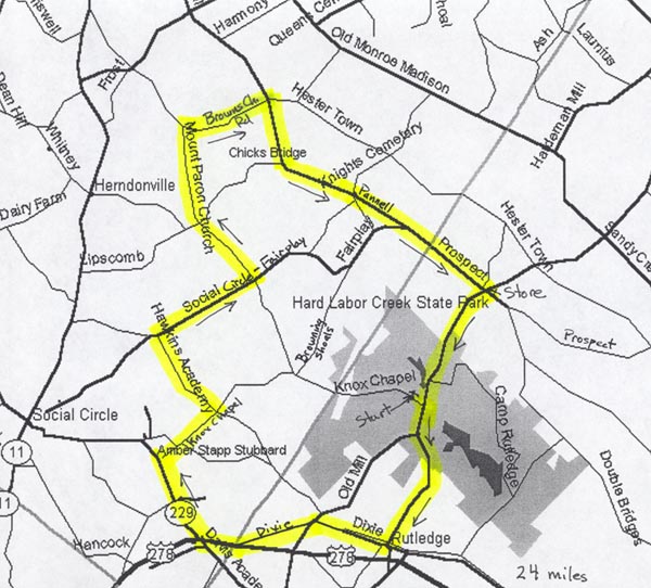
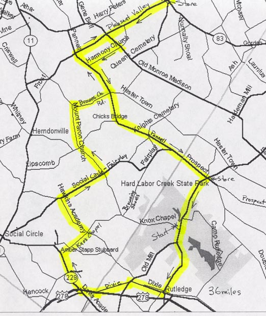
- Hard Labor
Creek State Park, 10-17-20-30,
30-50,
40-50-60,
43-55
- Hav-No-Gotta
- Helen Rides,
Soquee River,
Helen Tiger Loop,
Tour the Forest,
Helen Valley Ride
-
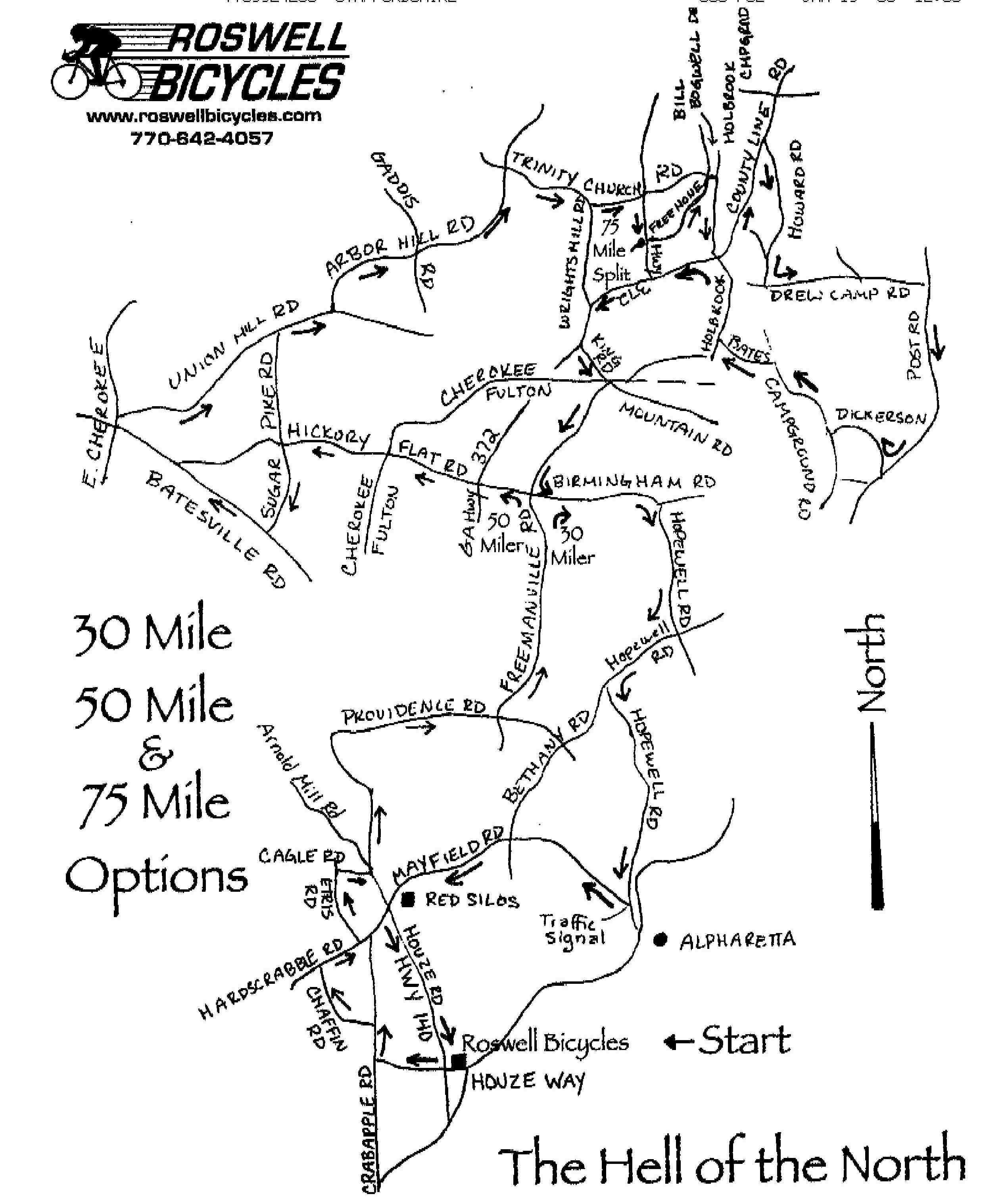
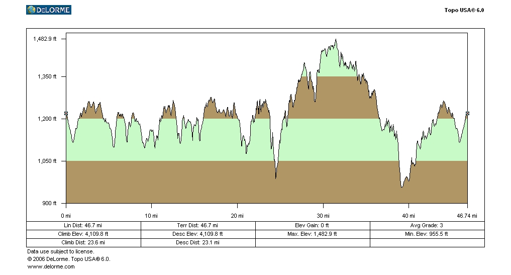
Hell of the North, starts at Roswell
Bicycles
- Hiram Rockmart Century
- Hiram Starts. Starts at Starbucks shopping center on 278 in Hiram,
Killer B 40,
Land of Sunsets Century,
Hiram to Acworth,
Hulsey Town
Hulsey Town Nuevo, March to the Sea
-
Hog Mountain, Gwinnett County
- Hogpen Elevation
-
Hospitality Highway/GA 400 Century/100,
9 mile,
30 mile,
60 mile,
2010 Overview,
2010 100 Miles,
2010 63 Miles,
2010 25 Miles,
2010 8 Miles
-
German Valley, Rabun County
-
Jittery Joes Ride, Buford
-
John's Mountain, Rome
-
Johnson Mountain Elevation
-
Judy's Birthday Routes, Starts at
Frankie's Restaurant in Rockmart
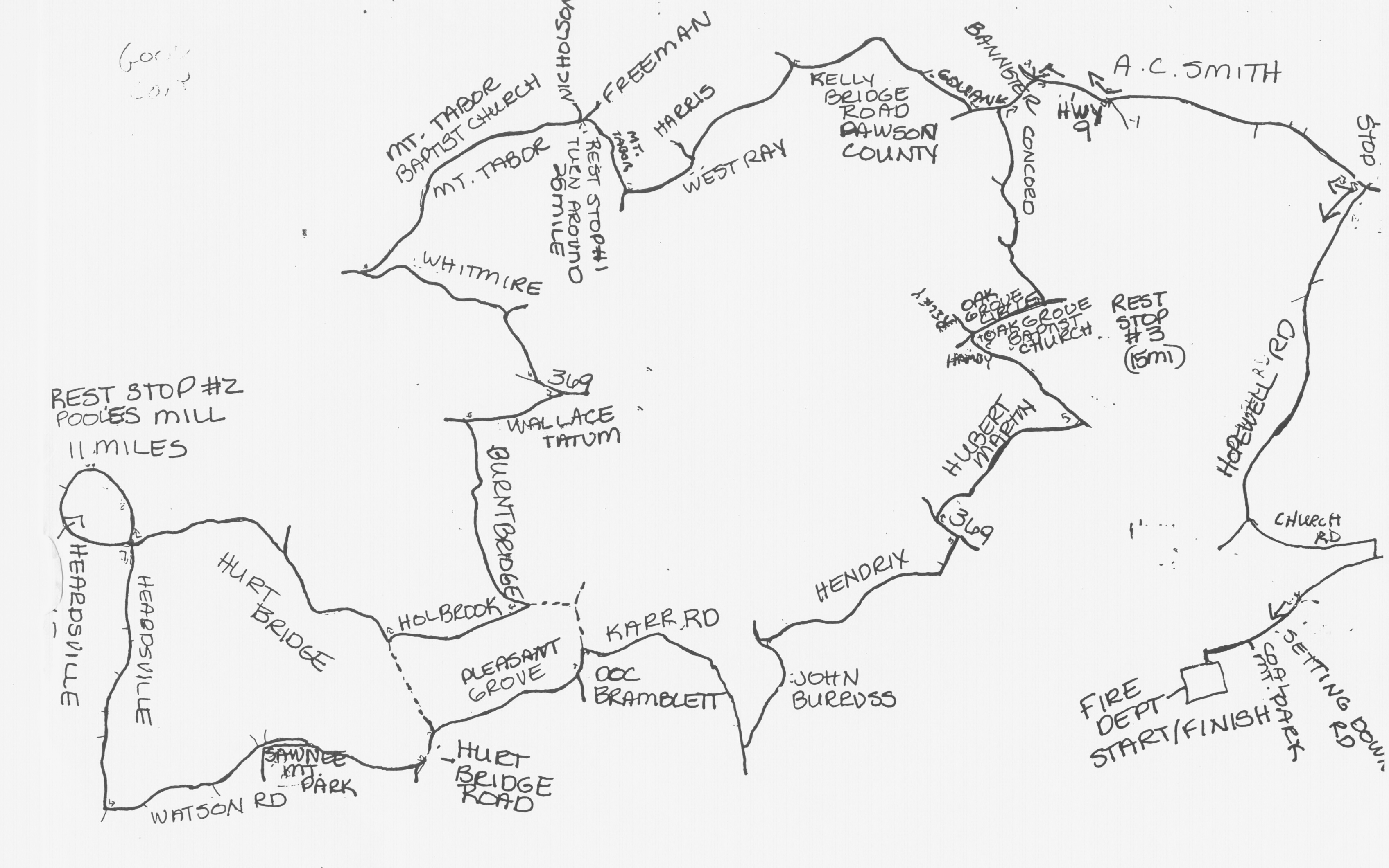
- Kelly Bridge,
Map,
Cue Sheet,
Profile
-
Kellytown, Stone Mountain
- Kennesaw Mountain Elevation
-
Kennesaw Mountain Ride Cue Sheet aka
Kennesaw Mountain Tri Ride
- Land of Sunsets 45 mile option (start in
downtown Rockmart)
- Lake Burton
-
Lake Rabun, Rabun County
-
Lifetime Fitness, Alpharetta Sunday
Ride, Saturday Ride,
Tuesday Night "A" Ride,
Tuesday Night Ride
-
Little Tennessee Valley, Rabun County
-
Mineral Bluff, Fall Leaf/Three State Ride
-
Monticello Scenic Byway
- Mountain Mania, Suches, GA
15 mile,
50 mile, 62 mile
- Mountain Rides,
Little Mountain 42,
Little Mountain 55,
Daves Ride
- Mt. Olivet Loop, From the Silver Comet Coots Lake Trailhead.
Word
Document. Adobe PDF.
- Nancy G's. Leaves from the Fountain
Oaks Shopping Center on Chastain Rd. in Atlanta.
- New Years Day Ride
- Newnan
23 Miles,
35 Miles,
41 Miles,
46 Miles, starts at Madras Middle School
-
Northstar Bicycles 20 and 40 Mile Rides
-
Outback Wed. Night Ride, Starts at Outback
Bikes in Little 5 Points
- Paulding County
Bike Shop Blue Loop Map,
Blue Loop Elevation,
Yellow Loop Map,
Mixed Gravel Loop,
Blue and Yellow Extension
-
Peachtree Battle
-
Peachtree Bikes Old Wednesday
Night Ride, starts at Peachtree Bikes
on Peachtree St.
- Pizza Farm Loop
-
Ridge and Valley Scenic Byway,
near Rome
- Rockmart Starts Land of Sunsets/NARC 45 Miler
-
Roswell, Roswell Mile High Map,
Mile High
Cue Sheet, starts at City Hall
-
Roswell Thursday Night Ride,
C Ride, 2010 A Ride,
2010 B Ride,
2010 C Ride
- Roswell Mayor's Ride,
20 Miles,
40 Miles,
Metric Century,
Cue Sheet
-
Roswell Park Ride
-
Round Rockmart
-
Russell-Brasstown
Scenic Byway, near Helen
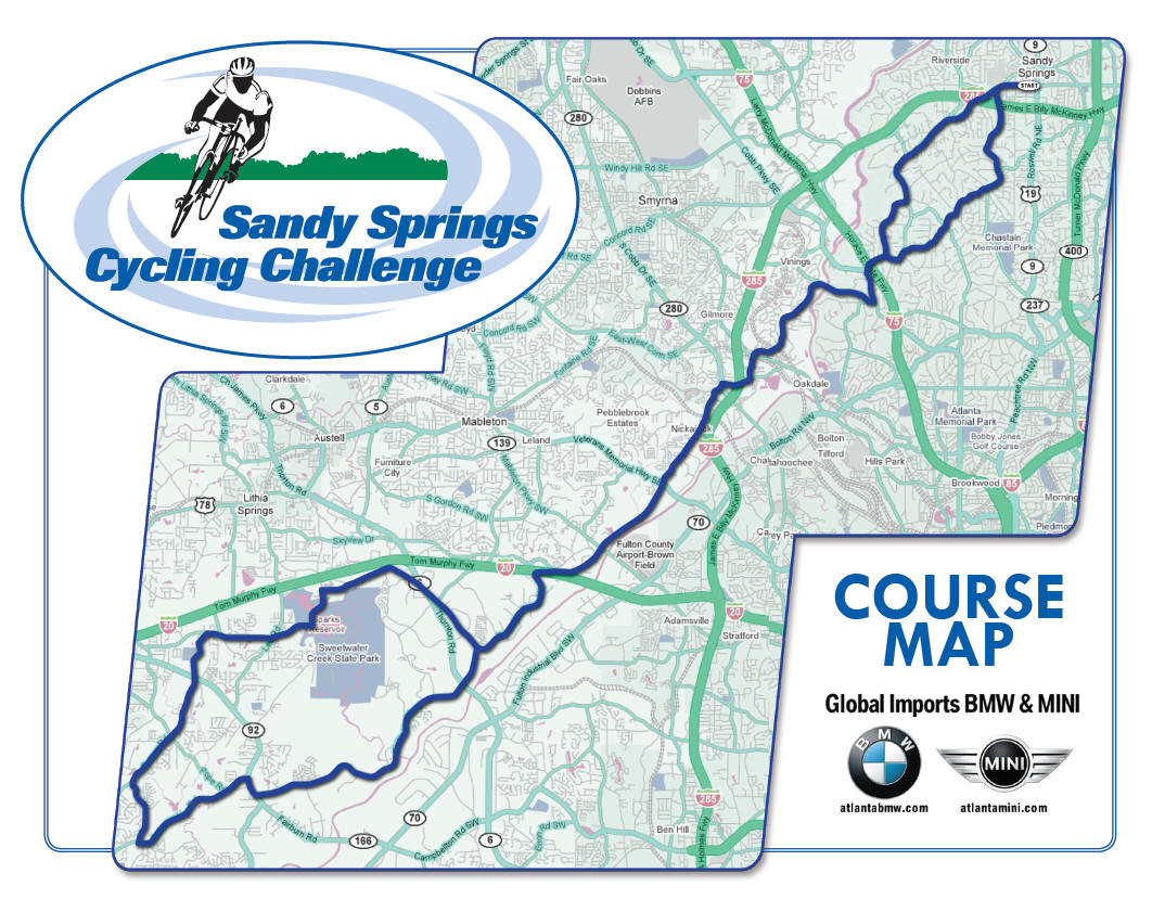
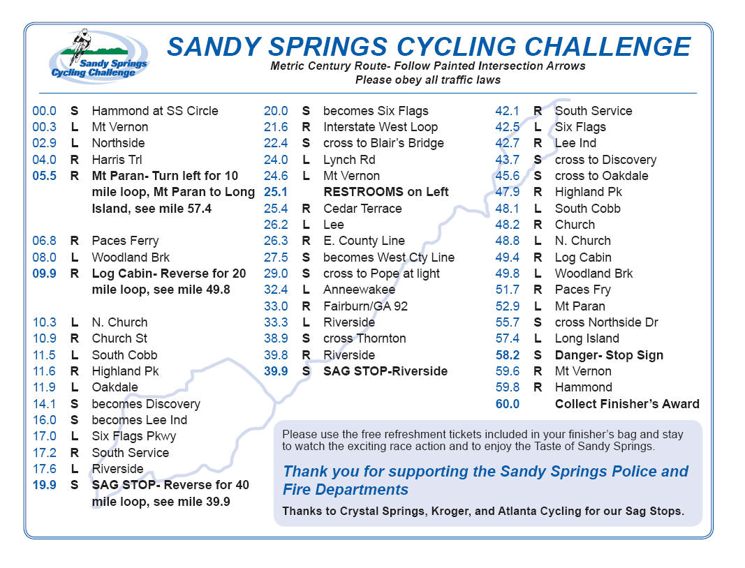
- Sandy Springs Metric Century
Map,
Cue Sheet
-
Sandy Springs Cycling Challenge
- SBL New
Year's Day Ride 2010 Map
-
Serenbe May Day Ride
-
Serebe/Silk Sheets Ride
- Serrano Century/Between Rides,
20 miles,
40 miles, 60
miles, 80 miles,
105 miles,
Cue Sheets,
Directions to start
-
Seven County
Century Red Loop, Yellow and Green
Loops
- Share the Road Century,
Cue Sheet
- Silk Sheets
Map 1, Map 2,
Elevation Profile,Silk
Sheets 54, Silk Sheets Sunday Ride 2009, Southern Fulton County
- Silver Comet Grits Ride Part 1,
Part 2
-
Silver Comet Elevation
-
Silver Comet Hiram-Alabama Century,
Elevation
-
Silver Comet Mt. Olivet Loop
-
Silver Comet-Other Routes
-
Silver
Lake, Buckhead
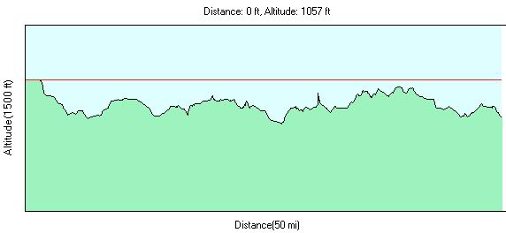
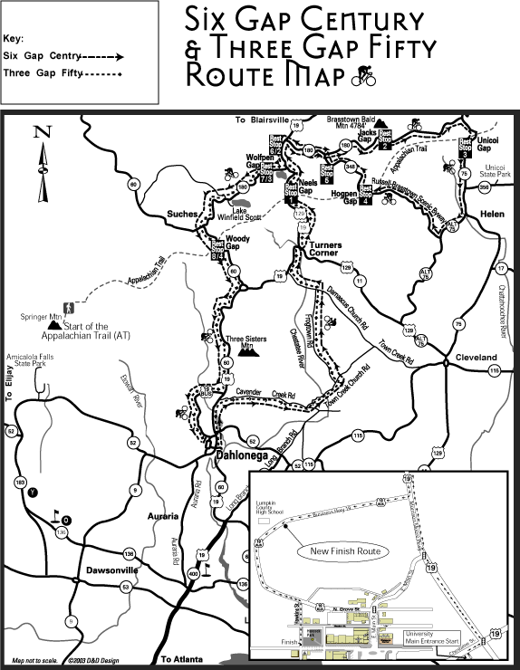
- Six Gap/Three Gap, Dahlonega,
Elevation
- Six Gap Map, Dahlonega (includes R Ranch)
-
Six Gap/Three Gap Map 2008
-
Sky Loop,
Cue Sheet, start at Starbucks on 278 in Hiram
- Social Circle Middle School,
25 miles,
37 miles,
49 miles, 59 miles,
66 miles
-
South Fulton Ramble
-
South Fulton Scenic Byway, Southern Fulton
County
- Steel Magnolias,
Steel Magnolias II, Sandy Springs
-
Stone Mountain Fun in the Promised Land
-
Stone Mountain Loops
-
Taylorsville-Cave Springs Loop
-
Ten Arena Tour, Intown Atlanta
-
Three Gap Cue Sheet, Wal-Mart Option,
Dahlonega, Elevation
-
Thursday Night Ride, Buckhead
-
Thursday Night Weekday World Cup
-
Tommy's Ten Gaps, Starts old Target on
Johnson Ferry Rd., Sandy Springs. Route by Tom Hanks
-
Toto Creek,
Directions to Toto Creek
- Tour De Cure, Tyron,
25 km,
50 km, 100 km
-
Tour De Rogers
- Tour De Pike,
18 miles,
33 miles,
66 miles,
100 miles,
Directions to Concord
-
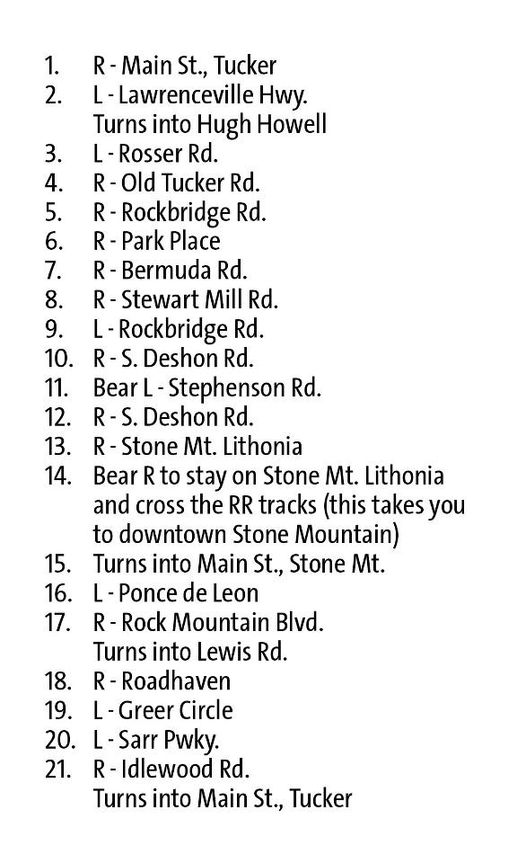
Tucker-Original
Route,
Tucker 2-Fall 2006,
Tucker Winter 2013
-
Tucker/Decatur to Helen
-
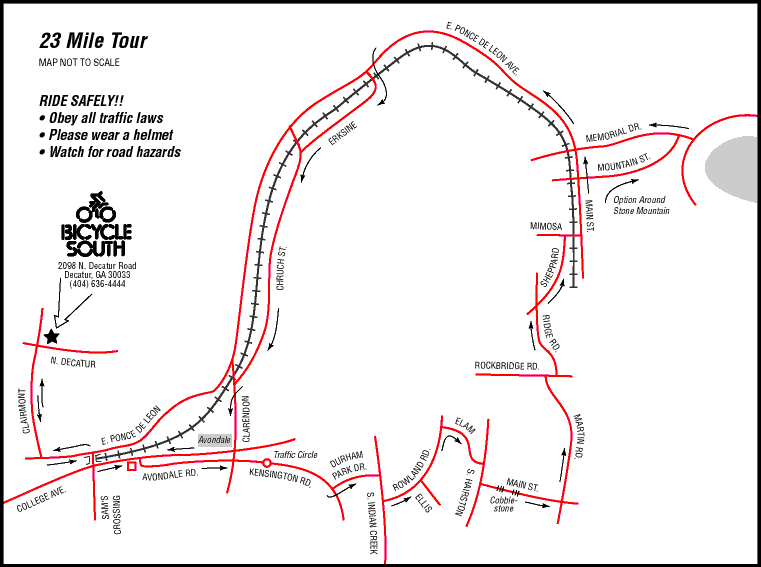
Atlanta Cycling Vinings Loop,
Cue Sheet
- Web Bridge
Map.
Sugar Pike Map,
Sugar Pike Cue Sheet,
Mt. Tabor Cut Sheet,
Alpharetta, Web Bridge Rd.
- Wednesday Women's Ride, Buckhead
-
West Georgia Escape
- West Georgia Flyers Rides,
Whine and Cheese
Ride, Pine Mountain Valley Route,
Smith's Mill-Oak Grove,
Salem Chipley,
Dennis Smith RR,
Greenville Loop 1,
Greenville Loop,
Brown Jug Ride,
Grantville Ride
- White, Bartow County
- Wilson 100
- Wisteria, Snellville
- Georgia Climbing Data
Gwinnett Touring Club Maps Courtesy
GTC
Classics:
Rides from Auburn, Georgia. Rides leave Auburn, GA police station
Rides from Bethlehem, GA. Leaves City Hall, Ride leaves from Bethlehem City
Hall parking lot. Take Rt. 316E. Take a right onto GA Rt. 11 and follow for ~ 1
mile. City Hall is on the left.
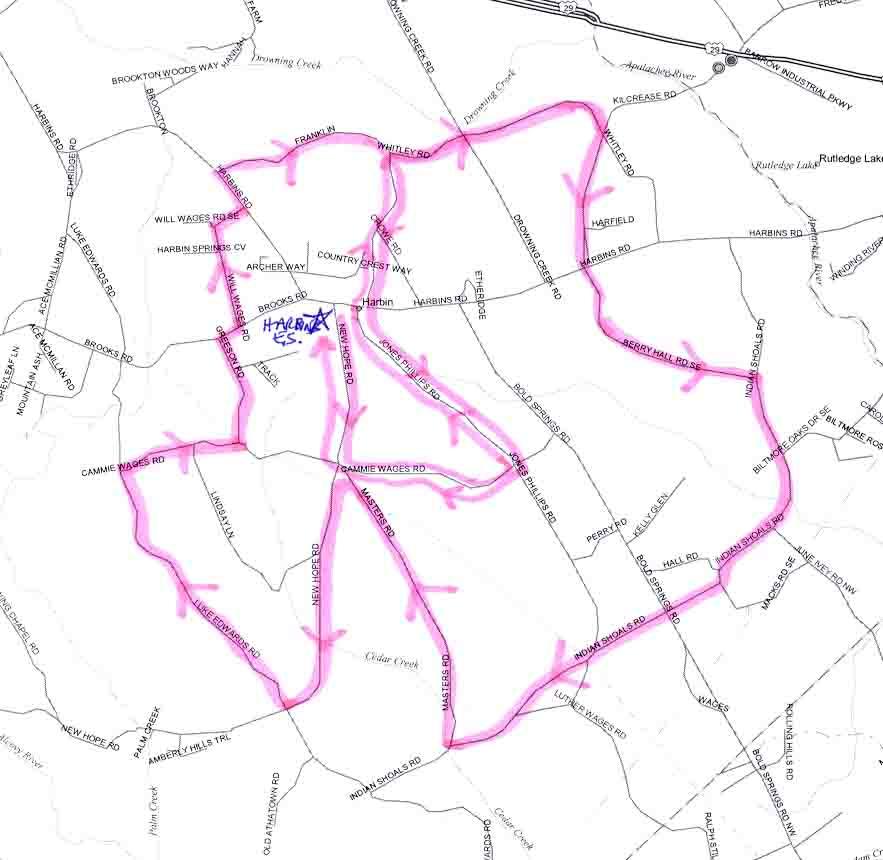
Rides from Harbins Elementary School, Take Route 316E towards Athens. Turn
right onto Harbins Road. Follow for approximately 4 miles and turn right onto
New Hope Road.
Rides from Ft. Yargo Elementary School, From I-85, take highway 316 east and
make a right on Patrick Mill road. Immediately turn left on Tom Miller road,
follow for 2 km and turn left on Haymon Morris road. Yargo ES is immediately on
the right.
Other Rides
Athens Area Maps
These maps are courtesy of the
Nitty Gritty Bike Band
- 4 Counties Loop
- 3 Forks 50
- Antioch Church Loops
- Beaverdam Classic
- Modified Beaverdam
Classic
- Bostwick Half Century
- Bostwick Mansion
Short Rides, 36 miler
- Brew to Brew Century
- Double Bridges 22 miles,
33 miles
- Double Wolf Loop de Loop
- Gino's Ride/Dagmar's
Hill
- Hard Labor Metric
Century
- Hard Labor 12 miles,
24 miles,
36 miles
- Hartwell Ride Map
1 (Athens Tech to Watson Mill)
- Hartwell Ride Map 2
(Watson Mill to Nuberg)
- Hartwell Ride Map 3 (Nuberg
to Camp)
- Hartwell Ride Map 4
(Camp to Nuberg)
- John and Jim's Sunday
Ride
- Keeping Your Wits About You
- Lake Oconee Loop
- Linda Vista
- Lucky Jones
- Madison Antebellum Tour
- Marjorie and Roger's Ride
- Monitcello
80/Union Chapel 50
- Ride To Nowhere 30 mile,
47 mile
- Rutledge Metric Century
- Savannah Area, Darien,
Ebenezer-Rincon,
Kilkenny,
Pooler, Pink Pig,
Ridgeland,
Springfield-Cylo
- Seven Islands
- Sorella Recovery Ride
- Southside Shuffle
- Southeast
Jackson/Cul De Sac
- Tour de Barnett Shoals
- Tour de Neese
- Watson Mill to Nuberg
- West Georgia 100,
66 mile, new
100 mile map, Starts from West Georgia College in Carrollton
- Winter Bike League Maps, Royston Classique,
Royston Cue Sheet,
Alto World Cup,
Alto Cue Sheet,
Alto Cue Sheet 2009,
Bowman,
Farmington,
Hard Labor,
Monroe,
Saul Sizzler,
Talmo,
Greensboro,
Madison Cue Sheet,
Madison Map,
Pendergrass,
Point Peter,
Commerce Roundabout,
Hudson Map,
Hudson Cue Sheet, Maysville
Map, Maysville Cue Sheet,
Monroe Map,
Monroe Cue Sheet,
Pendergrass Map,
Pendergrass Cue Sheet,
Talmo 2008 Map,
Talmo 2008 Directions,
Ultimate Thule,
Ethridge
Farm-Jackson Trail-Hoschton,
Commerce Classic,
Alto World Cup 2013
- Ride
Starts,
Ride
Starts in Athens
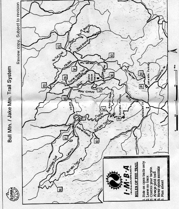
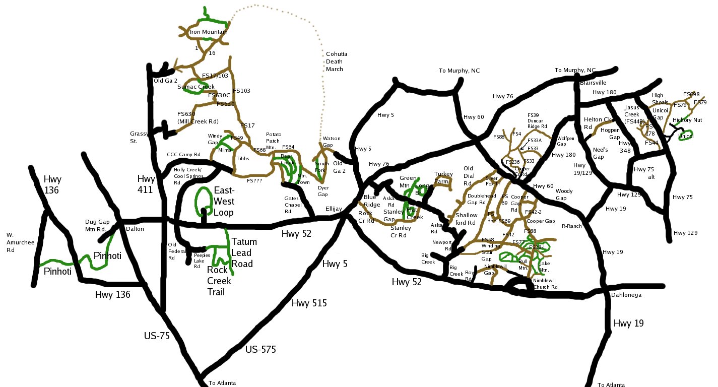
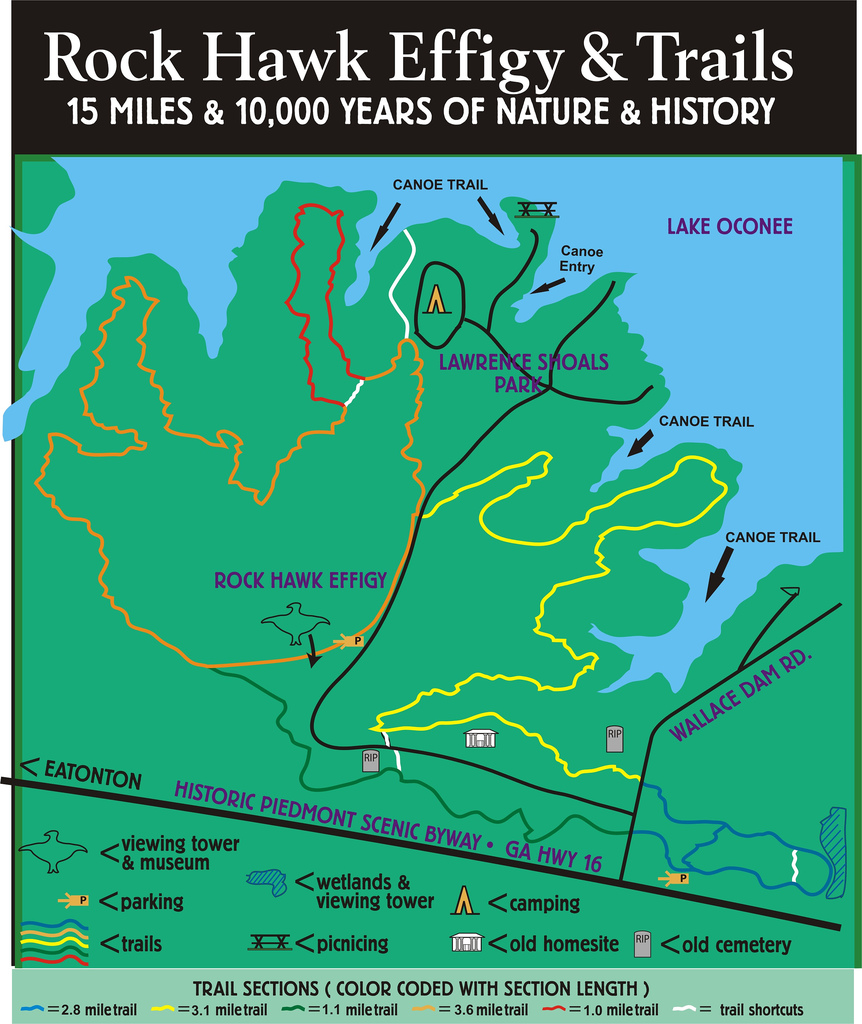
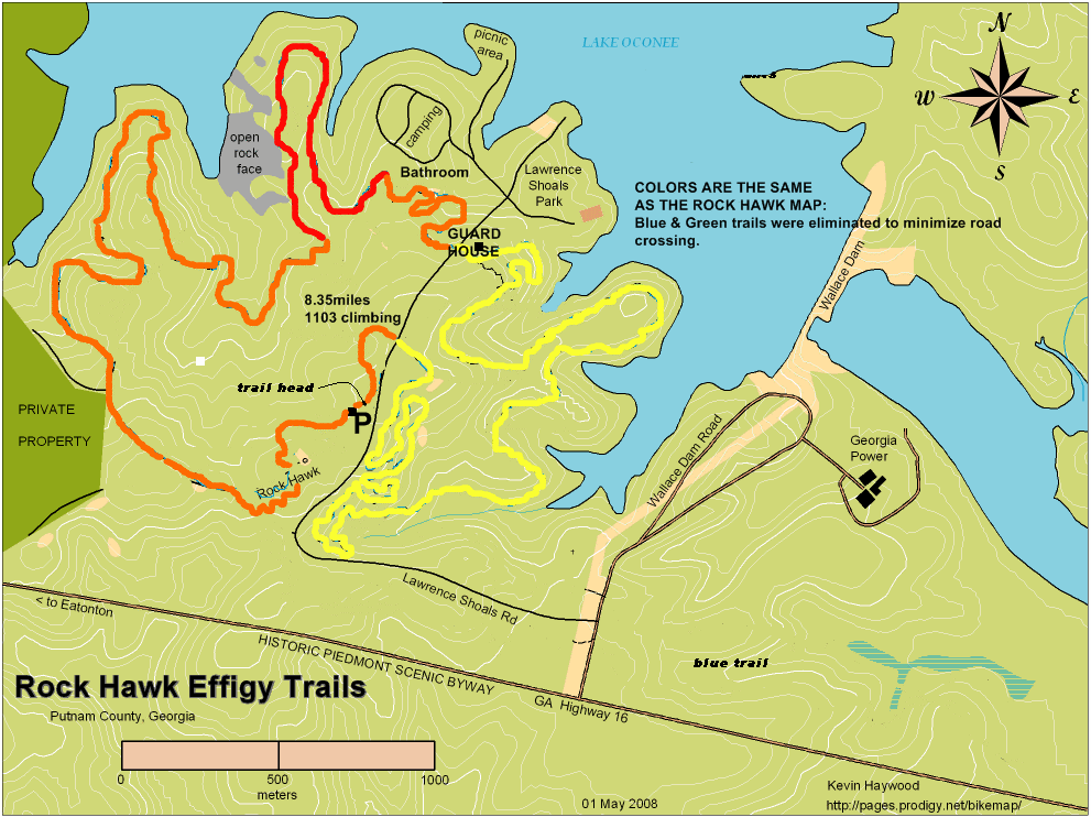
Mountain Bike Maps
Etc.
Disclaimer: Cycling is a dangerous sport. Trish Albert and Southeastern
Cycling are not responsible for the accuracy of the maps, if you get lost, if you get hurt while using the maps, or anything else that happens while riding your bike while using the maps.
All maps used with author's permission, if author known.
Special thanks to Coach Chris Andrus
for permission to use many of the PDF maps.
Special Thanks to Chris at Atlbike.org for
the elevation maps and the maps of Paulding County, Silver Comet, and the "Green
Team" rides.
Thanks to the Nitty Gritty Bike
Band for many of the maps of the Athens area. Thanks to Tommy Hanks for some
of the maps. Thanks to Larry for the Ball Ground cue sheets. |
